Prosperity and decline since antiquity
FeatureBy Deepika Kundaji
Keywords: Pebble Garden, Auroville history, Seed conservation, Aurobrindavan community, Environmental sustainability, Ecological biodiversity and Ecological restoration
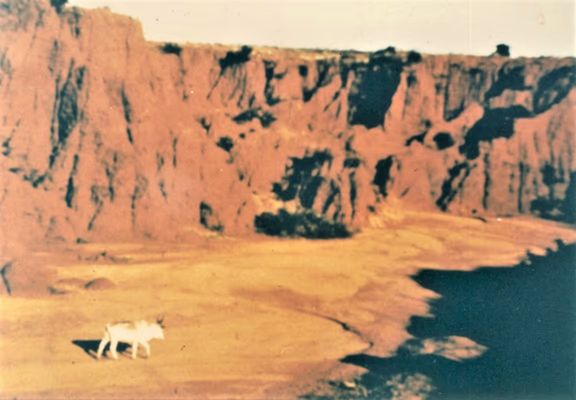
Beginning of Auroville – Canyons near Utility
Deepika Kundaji is known in India for her work in seed-conservation and land regeneration. She is regularly called on to conduct training for farmer groups and to speak about her work. Over the last 29 years, she and her partner Bernard have restored life and biodiversity to eight acres of severely eroded land at Pebble Garden in Aurobrindavan, Auroville. In 2018, the President of India conferred on her the Nari Shakti Award 2017, India’s prestigious award for women, for her work in the field of biodiversity and seed conservation.
Deepika has been studying historical sources to find out how the Auroville area became a desert and how an awareness of past ecological blunders can shape a conscious vision for the future.
PROSPERITY
A Contradiction
Two facts about the Auroville region are strikingly contradictory – the extreme decertified condition of the land at the beginning of Auroville and the antiquity of human occupation in this area.
Photographs from the early days of Auroville serve as harsh reminders of what the land was like 50 plus years ago – a scorched, red, treeless terrain scarred by gullies. By no measure could this land be called fertile, with canyons cutting through all sides of the Auroville plateau, eroded red soil, intense monsoons followed by long dry periods and no perennial water source. There are reports from back then of severe water scarcity in summers when residents of Edayanachavady had to walk to Kuilaypalayam to fetch drinking water. At least 8 sq kms of land west of Tindivanam Road from Aurobrindavan to Usteri Lake is even now highly eroded, with no topsoil whatsoever.
Was Auroville and the area around always a desert? If yes, then how could people have possibly inhabited this land for millennia? How did they manage their water and food? What can historical / archaeological evidence tell us about how people lived here in ancient times, what was the condition of the land and the environment?
Cairn Circles and Indian Ocean trade 2nd Century BCE
The cairn circles or pandukals right at the centre of Auroville testify to human presence on this plateau at least 2500 years ago and a society that was quite advanced. People who crafted iron, stone beads and terracotta objects surely had the basics of water, food and shelter behind them.
Arikamedu, close to Pondicherry, was a bustling international port from the 2nd century BCE to 7th century CE, connecting South India with West Asia and the Mediterranean world, as well as South East Asia and China. Luxury goods from this region, sought after in Greece and Rome, included fine textiles, gemstone beads, pepper, medicinal products, spices, pearls, monkeys, parrots and peacocks. The favoured products that came to Arikamedu from the West were olive oil and wine in Roman amphorae! This period overlapped with the time when cairn circle or pandukal builders were present in the Auroville area. There is specific mention of Ferrum Indicum (Indian Iron) and ‘Indian’ ebony among the 54 valued goods being taxed in Alexandria, both sought after for their unparalleled quality around the world. Ebony wood, from Diospyros ebenum, a tree native to this region (now almost extinct), was so prized worldwide in ancient times that it was offered as a tribute between kings, on a par with gifts of gold and silver.
Overseas trade and advanced seafaring skills assume agricultural surpluses, a range of well adapted crops and livestock, perfectly managed water resources and, of course, different kinds of trees to make different kinds of boats, ships and cargo vessels for varied merchandise. A complete and prosperous society that not just survived but thrived.
Overseas trade and mobility in Sangam poems
Several poems from the earliest Tamil texts, known as the Sangam literature dated between 600 BCE to 300 CE, mention ‘Yavana’ people and ‘Yavana’ ships – a word referring to the Greeks and Romans, but also to anyone from the West. Tamil inscriptions and artifacts of Indian origin have been found in Egypt, Oman, Thailand, Sumatra and China. Sangam poetry describes horses transported in ships from Arabia.
There were at least 36 kinds of boats and ships with unique names mentioned in the early Tamil texts, each needing specific kinds of wood, implying that diverse suitable trees were in abundance. Equally used were bullock carts (the chief means of inland transport) which, as described in the Pattinapalai, one of the Sangam anthologies, were built to perfection with “wheel hubs made from huge trees''.
The Sangam poetry contains picturesque depictions of the social and environmental landscape in those times. A five-fold land classification forms a thread running across many of the poetic verses describing the physical features of the land but also metaphorically the ‘inner landscape’ of people.
Traditional landscapes & cultural diversity
The five categories of land are Kurinji (mountain), Mullai (forests and grazing lands), Marudham (fertile agricultural land), Neythal (coastal) and Palai (desert). It is very interesting to note that Palai or desert lands were not a separate category of land but rather considered to be a degraded form or seasonal expression of Kurinji or Mullai lands.
Each of these regions and micro-regions were distinct ecological units or miniature worlds. The way in which people lived was shaped by the unique physio-geography and natural resources of each type of land. Everything about life, not just human life, emerged from the land and the Sangam poets describe this diversity and oneness with the land most beautifully.
The occupations, the kind of houses people lived in, the food they ate, the flowers they wore, the trees they used, the gods they worshiped, even the mood, temperament and dominant emotions of the people, were extended features of the land. Every region had its own natural advantages and people prospered by adapting to each with unique skills and tools, making every region as culturally distinct and as diverse as the landscape itself. Human life and diversity was embedded in and inseparable from the natural richness of a place.
For instance, the hunter gatherers of Mullai regions (forest and grassland) in the Tondaimandalam – the ancient name of the region in which Auroville is situated – are described to have been skilled in collecting grass grain (from rodent holes) which they pounded and cooked. A special meal served to visitors would consist of bold upland paddy with poriyal of monitor lizard.
They were skilled in hunting hare and wild boar. The Mullai pastoralists, on the other hand, apart from animal husbandry, also grew rainfed millets and their staple food was koozh (fermented ragi or kambu). They would serve guests a special meal of varagu rice with avare beans or thinai rice cooked with milk.
These descriptions are from the Sangam text Perumpaanatruppadai.
Auroville plateau as Mullai land
These Sangam descriptions strongly suggest that the Auroville plateau would traditionally have been characterised as Mullai – forest and grazing lands. This is supported by many current facts. Idayanchavadi gets its name from Idayars or pastoralists, and chavadi meaning a meeting place. Ragi and kambu_ koozh was the common food, until recently when free rice from the Public Distribution System invaded diets. Rainfed paddy varieties were still grown in the uplands when Auroville began. The wild vegetation mentioned in descriptions of Mullai lands is common in this area – icham, vengai, makilam, ookam grass. Mullai lands were named after the mullai flower – the wild jasmine (Jasminum angustifolium) whose flowers are ‘fragrant from afar’. Kaya (Memecylon umbellatum), kondrai (Cassia fistula) and thondrai (Gloriosa superba) are flowers typifying Mullai_ territory and are seasonal marvels of the regenerated forests of Auroville. The hunting of small game – hare, partridges, monitor lizards – was common in this area even 20 years ago and would not have existed without forested areas.
The natural lay of the land and the fact that the Auroville plateau slopes in three directions suggest that there must have been considerable forests on the uplands in order to preserve wildlife habitat, safeguard soil fertility, prevent silting up of water bodies and enable rainwater percolation.
Ecological wisdom in the Thirukkural
“Multi layered forests are the fortresses protecting life, ensuring crystal clear water and fertile soil.” Thirukkural (742)
This verse, from the classic Tamil Sangam treatise on the art of living, superbly sums up the foundational wisdom underlying life and prosperity in ancient Tamil Nadu. Protecting the environment was not seen as something separate from human well-being and development. The wisdom contained in the poems were not poetic abstractions but grounded in the lived reality of people in those times.
Looking at its relevance today, the Thirukkural is a forgotten guide to daily living, consistently emphasising an ecological way of life as being the ONLY way.
Rainfall and water management
There is no life without water. Society is entirely shaped by water, and prosperity in the region hinged on how effectively people managed excess rain and shortage through varied practices to ensure food and water all year round. Avaiyyar was very articulate about how water that was managed well in paddy fields was directly connected to the success of a king.
The Auroville area has no natural perennial water source like a river. We get a lot of rain annually – 1000 to 1200 mm on average. But there are only 40 to 50 rainy days in a year.
Often 1/6th or even 1/5th of the annual rainfall occurs in one day. This intensity can potentially turn the life-giving force of water into a destructive one. Intense wet periods followed by a very long dry season – this was the challenge people had to confront and manage.
Native ingenuity and engineering perfection is evident in the different kinds of water bodies – eri (irrigation tanks), kolam (ponds), open wells – that were made to hold rainwater during intense rainy spells and make it available during the dry season for agriculture, livestock and domestic use. In the Sangam literature, 47 names for specific kinds of water bodies are mentioned. There were precise terms for different kinds of water reservoirs used for irrigation – ilanchi, kayam, keni kottakam, madu, salandiram, eri, poykai, kuttam, kanmay etc.
The eri system
An eri is a reservoir created by an embankment strategically built between two ridges, in a location that has a good inflow of water during the monsoon. Once an eri is full during heavy rains, the overflow becomes the inflow for the lower eri. In this way entire drainage basins or watersheds were ‘landscaped’ into a linked chain of eris, making it possible to capture maximum rainwater and reduce wasteful runoff. The stored water was then used to irrigate fields in the lower areas by means of sluice gates and through distribution channels. In all probability, the Cholas supported the construction of these engineering marvels, which were then maintained by the village community as a common asset, that in turn supported the king as well.
The lands irrigated by the eri could grow finer varieties of paddy and sugarcane. These were normally grown on fertile agricultural Marutham lands on alluvial soils irrigated by canal distribution systems from rivers.
The eri system made it possible for agriculture to develop and thrive and support human life even in relatively dry areas where no perennial rivers flowed.
Each eri was scrupulously maintained by the local people – sluice gates and embankments repaired. Desilting was carried out annually to maintain the water holding capacity and at the same time to fertilise the rainfed upland fields. Silting up of water bodies was minimised in the past by maintaining forest cover on the uplands, particularly at the top of the watershed.
Abundance in the songs of Irumbai
The ancient Mahakaleshwarar temple, near the Irumbai eri, the biggest in the Auroville area, was visited by Sambandar, one of the three 7th century CE Shaivite saints who composed the Thevaram. Sambandar composed 11 verses in praise of the Irumbai deity. Three of the verses describe the surroundings of the temple – mentioning trees so tall that they touch the sky and gardens on which the clouds settle, honey flowing, monkeys feasting on jackfruits and playing on tall trees: an environment of prosperity and plenty.
The inscriptions in old temples in this area – at Irumbai, Kiliyanur, Arisili – mostly record donations of goats, sheep, cows and sometimes grain to sponsor the lighting of lamps at the temple. Agriculture and animal husbandry flourished in the 7th century.
The Kaduveli siddhar, who is associated with the temple of Irumbai, usually inhabited forested areas, like other siddhars. Their yogic practice gave them insights into the healing properties of wild plants that surrounded them. Of the local TDEF (Tropical Dry Evergreen Forest) species, 150 have documented medicinal properties and are traditionally used to treat more than 52 human ailments. It was only because the siddhars were immersed in the living surroundings of forested areas that this knowledge developed and could be used to heal and serve people.
Wealth of India and the Coromandel Coast
Herodotus back in the 5th century BCE had pronounced India to be the “wealthiest country on the face of the earth”. Millennia before its ‘discovery’ by Western Europeans, India’s natural commodities and exquisite artisanal products – silk and cotton textiles, steel, spices, timber, gemstones, pearls – had lured seafaring traders from distant lands in Arabia, Egypt, Persia, Africa, South East Asia and China, apart from Mediterranean Europe.
The Coromandel Coast (Cholamandal, to be correct) was strategic for seafarers navigating these distant continents, serving as a fulcrum of trade in the Indian Ocean. The Portuguese were well settled in Madras and Nagapattinam in 1522. By the end of the 1600s, other European fortified trading settlements (called ‘factories’) were established along this coast – the Dutch East India Company at Pulicat and Sadras, the Danish at Tranquebar, the French in Pondicherry and the English in Madras Fort St. George and Cuddalore Fort St. David.
As these trading centres evolved into expanding territorial powers, a large body of written material was created to inform European administrators and officials posted in different districts about the region. These reports, manuals, gazetteers, handbooks, journal articles and guidebooks throw detailed light on subjects like crop diversity, agricultural practices, forest trees and valuable species, water harvesting and water lifting devices, blacksmithing expertise and pearl fishery skills, to name a few subjects.
Indigenous agriculture described in colonial records
Francis Buchanan, a Scottish physician and naturalist, was commissioned by the British East India Company to tour the lands which had been under Tipu Sultan after his defeat in 1799. He started his journey in Madras and in his travel account of 1807 writes about the Sembarambakkam eri near Madras, “...it supplies with water the lands of thirty two villages (should the rains fail) for eighteen months. (...) In a country liable to famine from want of rain, a reservoir such as this is of inestimable value.” He describes what people do during heavy rain spells, losing no opportunity to increase the water holding capacity of the eri, and how they then monitor the situation day and night during heavy rain to avoid breaches and flooding. He describes the upland as being too stony and dry for any cultivation, but where palmyra and wild date abound and where forest trees would be beneficial, if introduced.
Almost all the early colonial records describe an advanced indigenous agriculture whose success was the result of three synchronised elements: 1) efficient water management; 2) appropriate land use systems that took into consideration topography and the place and role of forests and trees in agriculture; and 3) farmers’ ingenuity in developing and using crop cultivars and livestock breeds for a range of specific uses and unique field conditions.
For example, in 1878, farmers of South Arcot District (now Villupuram and Cuddalore districts) cultivated 40 varieties of rice and several millets including panikambu – a variety of pearl millet – that could grow post monsoon with just dew. Although paddy is a wetland crop, farmers had developed varieties like pulthikar that could grow on uplands with minimal field preparation and not a drop of artificial irrigation. At the same time, in contrast, there were four long stemmed varieties of paddy that were grown inside irrigation tanks. They have “stem lengths that vary from three to nine feet according to the depth of the water,” records Garstin in 1878 in the Manual of South Arcot. Even thirty five years ago, Aurovilians spotted these long stemmed varieties growing inside a tank near Kasipalayam.
The creative way in which farmers used plant varieties to the maximum advantage is illustrated in an extinct traditional practice, recorded in the Gazetteer of South Arcot in 1906, of growing two varieties of paddy (ottadam and kar – of 8 and 3 months duration) in the same field. “The seeds are mixed, sown together and transplanted mixed in the same field. When the kar matures it is harvested and removed. The ottadam has not by this time put out any ears and so it suffers no injury from the harvest.” This practice, if revived, could have immense contemporary relevance, given that the movement to revive traditional seeds and agriculture has gained momentum.
In 1897, J.A Voelcker, an agricultural chemist from England, was called to India on a special assignment to suggest how to improve Indian agriculture. After travelling the country, he says, “I do not share the opinions which have been expressed as to Indian agriculture being as a whole primitive and backwards, but I believe that in many parts there is little or nothing that can be improved. (...) Taking everything together, and more especially considering the conditions under which Indian crops are grown, they are wonderfully good.”
Productivity of indigenous agriculture
Exceptionally high agricultural yields were reported in pre-British and colonial times. The average produce from lands of various kinds in South Arcot District for the Chola period (10th – 13th century CE) was estimated to be around 33 quintals per hectare. Based on data collected by British engineer Thomas Barnard between the years 1762 to 1766 of nearly 2,000 localities in the Chengalpet taluk, noted historian Dharampal analysed paddy production figures from 800 villages and brought out some staggering truths about agricultural productivity.
Of the 800 villages, 130 villages with irrigated lands showed average yields of more than 50 quintals of paddy per hectare. Among these 130 villages, many produced more than 100 quintals of paddy per hectare. Average productivity of these 130 villages with 7,000 hectares of cultivated paddy was as high as 82 quintals per hectare. These yields are from Chengalpet lands which are of moderate fertility in comparison to delta areas like Thanjavur. The reported maximum yields around the same areas today, with chemical inputs and modern varieties, is about 65 quintals per hectare in eri irrigated lands and 49 q/ha in well irrigated lands.
How did traditional farmers get such high yields? Why is there such a decline in modern times despite ‘scientific improvements’? These are significant questions to ask today as the challenge of food production for a growing population keeps coming up.
An explanation for high yields may likely be found by looking not only at what was happening on the farms, but at the context surrounding them – the way in which the total land in each area was used. In the 800 villages, Dharampal writes that “The total cultivated area in these villages is about 54,000 hectares. The area covered under various sources of irrigation amounted to 26,000 hectares. Another 18,000 hectares was under forest. This high proportion of greenery and water perhaps creates conditions where high productivity becomes more easily possible.”
It has been reported that by 1871, within 100 years of colonial rule, the land use patterns in the same region drastically changed, with 83% of the land brought under cultivation.
DECLINE
Changing land use: industrial crops
The introduction and promotion of ‘cash’ crops or ‘industrial’ crops for export was the major reason for forest land being brought under cultivation. People were granted patta or ownership of lands if they cleared ‘scrub jungle’ or land categorised as ‘uncultivated wastelands’ and planted industrial crops. In South Arcot district, these were indigo (for the textile industry), ground nut (exported to Marseilles for the soap industry), sugarcane (for sugar – Nellikuppam factory from 1842), tobacco, casuarina (after 1882 for railway fuel) and cashew. This necessarily meant a significant reduction in the forest cover.
The holistic view of life and land use – integral to the indigenous way of life for millennia, where native wisdom acknowledged the role of forests in preserving soil fertility, providing water and supporting all life – had started to erode from the base. The process of falling farm productivity and agricultural decline had commenced. Forces of ‘development’ were chipping away at the foundations of agricultural and societal wealth that had long brought prosperity to these lands.
Building the city of Pondicherry and its needs
According to the Gazetteer of Pondicherry, in 1703 “Francois Martin who acquired Kalapet village, then famous for its timber, from Nawab Dawood Khan is reported to have used the wood from its forest for building houses in the town newly founded by him. The origin of ravines in Kalapet may perhaps be attributed to this process of depletion.” It is believed that it took barely 10 years for the canyons to form, after the cutting of the forests. Soil erosion resulting in canyon formation is the most extreme and irreversible form of land degradation, where soil is transported away from its place of origin, in this case ending up at the bottom of the Bay of Bengal. The Utility canyons of Auroville perhaps owe their origin to the same phase of deforestation. Given the canyons all around Auroville, it takes some imagination to picture what the place must have looked like before this immense loss of soil.
Nearly 30,000 people came to live in Pondicherry after Francois Martin’s efforts to develop the town, most of whom worked for the French to produce textiles for trade, ‘piece goods’ as they were called, and various kinds of ordinary and luxury fabric. Brocade, chintzes, velvet and cotton woven with gold thread were some of the luxury textiles with which outbound ships were loaded. The town was occupied by weavers and bleachers, yarn dyers and fabric painters. Coarse cottons, scarlet, blue and green dyed broadcloth were also produced in Pondicherry. Textiles took priority, replacing spices that initially attracted Europeans to India and the East. Indian textiles were in fact traded in SouthEast Asia for spices, being used as a currency of sorts. Pondicherry saw ships landing from and taking off to Mocha (Yemen), Pegu (Myanmar), Manilla (Philippines), Mascareigne (near Madagascar), Macao (China), and other parts of India, like Chandannagar in Bengal.
The houses in Pondicherry’s ‘White Town’ area were built of wood, brick and lime, some double storeyed. By 1735, there were 80,000 inhabitants. A trading town had its need of timber for ship repairs and for house building, and this was sourced from “The surrounding forests and woods, filled with deer and wild pigs, hare and partridges (…) which the Europeans loved to hunt.” The French Governor Dupleix used to favour the forested environs of Morattandi and resided there regularly. Red-wood (Red sanders) was sought after as a luxury timber and ships laden with‘red-wood’ are mentioned in Rangapillai diaries. The ‘ebenistes’ derived their name from ebony – a wood favoured in mid 17th century Paris for luxury cabinets. Ebony was also probably sourced from the forests around Pondicherry as, together with Red sanders, it was a tree native to this area, until it went extinct. Charcoal was the preferred fuel of the Europeans residing in Pondicherry. Rangapillai in 1748 mentions that the jungles of Mattur (in the Auroville area) “were cut down by our Company’s people for charcoal”.
Charcoal was so sought after that kilns were plundered. ‘Parc à Charbon’ was the old name of the area where the present Park Guest House is located in Pondicherry – possibly a charcoal godown or a place where charcoal was made.
Wars between the English and the French were so devastating that entire cities were razed to the ground after a defeat. Rangapillai notes the “smell of burning timber” after the English took Pondicherry in 1761. Three times the French lost Pondicherry – in 1761, 1778 and 1793. The town had to be rebuilt from scratch each time it was destroyed. The environmental costs of war are unestimated. However, neighbouring forests are always the first to bear the brunt of reconstruction, and the ripple effects of deforestation have far reaching consequences.
Internal mobility
To extend the area and depth of dominance, the English prioritised improving inland transportation through canal systems like the Buckingham Canal connecting South Arcot with Vijaywada and Kakinada, road development with the first highway in 1836 from Calcutta to Delhi, and eventually the railways.
For centuries, pack bullock caravans driven mostly by lambadis (a nomadic ethnic group also known as banjaras) were the most ubiquitous means of land transport, functioning extensively. Scenes of these caravans are brought alive in a sangam poem describing a woman with a child in her arms driving a bullock cart carrying salt inland. Rangapillai mentions 468 bullock cart loads of paddy, apart from other food grain and essentials, entering the Pondicherry bazaar in one single day. However, the shortcoming of draft bullocks for a colonial economy driven by growth was that for three months during the monsoon no carts could ply to and fro on mud roads.
Porto Novo Iron Works and the projected railway
In 1830 a civil servant named Josiah Marshall Heath working for the East India Company in Madras, proposed to invest in and build the country’s first large-scale iron factory on the Coromandel coast. He had carefully studied the legendary native wootz steel technology and, based on the insights he gained, came up with proposed methods to scale up this kind of iron production.
The Salem ores were studied and found to be of excellent quality. The company directors supported Heath’s enterprise because steel availability on a large scale was promising for the manufacture of rails for the projected Madras Railway. Heath was given a grant of 9,000 pounds, permission to source iron ore from 98,500 sq km in the Salem hills, and granted the right to cut the entire South and North Arcot jungles for all the fuel required for the production of iron. All this without any payment.
The factory started functioning in 1830 at Porto Novo (now known as Parangipettai, 65 km from Auroville), known initially as the Porto Novo Iron Works, located on the bank of the Vellar river, half a mile from the sea. Four blast furnaces produced iron considered equal to the best Swedish iron. After producing fine steel for nearly 30 years, providing for all the iron needs of Britain and British India, the company went into a tailspin. The harsh truth was that there was simply no fuelwood left.
Deforestation and forest conservancy
Vast tracts of land throughout the entire Madras Presidency were deforested and valuable timber indiscriminately cut for firewood and charcoal to feed the Porto Novo Iron Company. There is every reason to infer that Auroville area forests were also axed during this period from the 1830s to the 1860s. This devastation is well documented and criticised by almost all British officers posted in South Arcot district. The Imperial Gazetteer of 1908 states that the forests of South Arcot are not at present important as timber producing areas as they had been completely ruined before conservation began.
The jungles leased to the factory were under the District Collectors. Farmers were given free patta of a piece of jungle. They were allowed to clear it for cultivation, and the crops from these cleared lands were not taxed for two years. After two years of cultivation, the same farmers would apply for new tracts of jungle. They converted all the cut forest into charcoal, profiting from its sale to the iron factory and from tax free crops. “The jungles disappeared year after year.”
The British, acknowledging the devastation, started regulating the cutting of firewood and timber by 1860, and Jungle Conservancy Rules were introduced by 1862. On the advice of Dietrich Brandis, the first Forest Acts were passed in 1882. The chief objective at that time was to provide a permanent supply of fuel for the railways. W. Francis in the Gazetteer of South Arcot notes that at the same time Casuarina and Acacia auriculiformis plantations were introduced, to provide for the railway and at the same time to protect valuable trees such as Pterocarpus sp, Terminalia tomentosa, Hardwickia binata (one of the hardest and heaviest timbers in all India), rosewood and sandalwood.
Railway or ‘timber way’?
The devastating environmental impact the railways must have had on the whole country is unimaginable. If just the production of steel for tracks at Porto Novo succeeded in removing all traces of forests in South Arcot district, imagine the impact of cutting through thousands of miles of densely forested tracts across the country to lay railway tracks. The very first railway line of the country was operational in 1837, running from Red Hills to Chintadripet to transport stones for road building work in Madras. Not a trace remains of the ‘six forests’ or Aar kadu that gave Arcot district its name.
For a long time, railway ‘sleepers’, which function as spacers to hold the tracks in position, were made of heavy timber. The size of planed timber for sleepers was 10 ft x 10 in x 5 in, only specified hard trees were used, and they had a life span of just 20 years. As these were placed at close intervals, some engineers referred to the railway track as the ‘Timber Road’. The carriages, too, were initially made with wood. Finally, the fuel required to run the locomotives was initially wood charcoal.
Industrialisation of life
The Industrial Revolution and its unimpeded spread was a consequence of colonial expansion and consolidation. Innovators in Europe developed technologies that shifted production from hand methods to machine manufacture. Obviously this shifted the economic advantage squarely in favour of the inventors of machine technology.
For Indians this led to the collapse of highly skilled age-old occupations and drove to extinction exquisite handcrafted products that had gained widespread legendary status since ancient times. Whether it was Indian dyes and weaves or the muslins so fine that they bore names like ‘evening dew’, ‘running water’ and ‘webs of woven wind’. Or the wootz steel that travelled across continents to make the famed Damascus swords used by the Egyptians. It all came to an end with mass produced goods.
In Pondicherry, the Savana Mill was one of the earliest mechanised mills in the country, started in 1828 and powered by steam. Thousands of artisans involved in cotton spinning, dyeing and weaving lost their occupations when their traditional crafts, honed to perfection over time, turned sadly obsolete. Today even those mills stand in ruins.
Environmentally, these production methods were devastating because all fuel at that time was wood/charcoal based and the forest wealth of the country was plundered.
As underground mining and prospecting developed, fossil fuels took the place of wood. The pillage merely shifted underground. Today, society is grappling more than ever with the impact of over-exploitation of underground resources – whether petroleum, coal, water or minerals.
Nation building the regenerative way
After Independence, we embraced the colonial legacy of an industrial way of life, characterised by unbridled growth and consumption – an economic system that is intrinsically socially and environmentally exploitative – rather than revert to and reinvent an indigenous way of life based on decentralised rural industries with sound ecological foundations.
Sri Aurobindo, in his 1908 essay entitled Back to the Land, wrote, “The life of a nation is always rooted in its villages but that of India is so deeply and persistently rooted there that no change or revolution can ever substitute for this source of sap and life the Western system which makes the city the centre and the village a mere feeder of the city.”
Auroville inherited a ruined land, plundered by deforestation from the 1700s. The Auroville canyons, now hidden in part under a cloak of green, still testify to the tonnes of soil that the land lost to the sea. An irretrievable loss.
Forests were an integral part of the traditional pre-colonial / pre-industrial landscape of Auroville. They were indispensable for continued human existence on this dry plateau. Mullai or forested lands existed side by side with eri and well irrigated fields. It was this combination of forests and fields that ensured water, preserved soil and made it possible for people to harvest crops, raise livestock, hunt, gather and prosper here for millennia. This wisdom is preserved in the Thirukkural. Contemporary studies based on the 1760s Chengalpattu survey have shown how changing land use patterns – reduced forest cover and shrinking water bodies – led to a decline in agricultural productivity, even though the area designated as ‘cultivated’ land evidently increased.
The problems of desertification and soil erosion caused by deforestation continue to be issues of grave national concern. As Sri Aurobindo noted in the same 1908 essay, “It is an ascertained principle of national existence that only by keeping possession of the soil can a nation persist,” and “...with the loss of soil (…) the source of life and permanence is sacrificed.”
Today, of India’s land mass of 329 million hectares, 147 million hectares of land are degraded. This includes 93 million hectares of land severely affected by water erosion and ravine formation – almost one third of the total land mass. In this larger context, the re-greening of Auroville stands out as an exemplary prototype showing how such heavily eroded lands deemed ‘unfit for biotic production’ can be dramatically regenerated. It is standing proof that the devastating effects of past ecological blunders can be mended, if not entirely reversed. In the long run the forests will undoubtedly build soil again, revive soil life and restore fertility to denuded farm lands.
As a pioneering effort, the eco-restoration work of Auroville has inspired and supported reforestation projects across India. Through several training programmes over decades for officers from the Indian Forest Service, Forest Department staff, farmers collectives and grass-root organisations, the knowledge and skills required for this work have been shared.
Ecology and the ideals of Auroville
This ‘city the earth needs’ has drawn many seekers, in search of a harmonious way of living – as humans in our larger natural home. Disenchanted with the alienation that urban/industrial society engenders, of human existence as separate from the natural environment, many have come to Auroville aspiring for a new society, a new world. Nothing exists in isolation and human life and well-being is inseparable from the well-being of all other life forms. Seeking a change of consciousness to break that illusion of separateness at all levels of our existence, the ecological quest is embedded in the purpose and goal of Auroville.