Last year’s extraordinary rainfall and its consequences
An interview with GiulioBy Carel
Keywords: Climate change, Matrimandir Lake, Geomatics, Centre for Scientific Research (CSR), Aquifers, Groundwater monitoring and Cuddalore
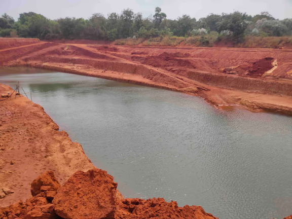
Rainwater and groundwater partially filled up the 10 metres deep test pond at the Matrimandir
With distressing regularity Auroville Today has been reporting on the challenges of providing water to Auroville’s inhabitants and those living in the region around. The 2015 June-July issue (# 311-312) was all about “The Water Challenge”. Two years later, the front page was titled “Auroville is facing a drought” (issue #335-336); and again two years later we reported that “A severe water crisis is expected” (issue # 358), as wells were falling dry and salinisation of the aquifer was happening. What’s the situation today? Here, Giulio gives his views.
The wettest year in a century
According to Charlie from Aurogreen, who has been keeping rainfall data for the last 44 years, 2021 was the wettest year ever. The Pondicherry meteorological department even speaks about the wettest in a century.
Our area has normally two monsoons, the southwest monsoon from June to September and the northeast monsoon from October to December. On average, there are 47 rainfall days, and about 1240 mm of rain is annually accumulated. But 2021 was different with massive downpours happening in normally dry months. For example, on the Mother’s birthday, February 21st, 2021, we had 180 mm, which is amazing! And it continued to rain throughout the year, with only a small break in March and April. The highest rainfall was recorded at Invocation and measured 2,985 mm, more than double the average.
But all that water didn’t percolate in the aquifer. For if it rains for a prolonged time, the soil remains wet and that reduces its capacity to absorb water. Most of Auroville has red soil, which has a permeation capacity of less than 20%. This means that less than 20% of the rainwater reaches the water table of the first aquifer; about 80% runs off. That’s what happened last year. And that explains why we need to build as many rainwater catchment ponds as possible.
But even that small amount of percolation fully saturated the first aquifer. This aquifer lies underneath more than 75% of the Master Plan area of Auroville. It suffers from over-extraction and was empty the year before. But in 2021, it got filled. This was clearly visible at the Matrimandir Lake test pond which was partially filled up by rain water and a rise in the ground water level.
Now there are a few things to keep in mind: there was a large volume of rain over an extended period; there were massive downpours; and because of this, the pumps fell silent and there was no groundwater extraction. All this contributed to the rise of the water level in many wells in the Auroville area. But this won’t last. I expect the first aquifer will become empty again before the onset of the next winter monsoon. It might even happen earlier. Our data are already showing that likelihood.
Wet floors and inundated meditation rooms
The increase of the water table had unexpected impacts. The floors of quite a few houses became wet and stayed so for a long time. And groundwater welled up inside the twelve meditation rooms in the petals around the Matrimandir. The water inside was at the same level as in the test pond.
The Matrimandir itself has an underground tank below it, from where excess rainwater is pumped out. But the Matrimandir petals have no slab foundation, which would prevent groundwater entering the meditation chambers. Evidently, nobody ever expected that the groundwater would rise so high that it would well up inside the meditation rooms.
Some people suggested creating an emergency opening to ensure a speedy outflow from the petals – they do not have a drainage facility – as they were concerned about the petals’ structural stability. I advised against it, firstly because the water in the petals was groundwater and the petals would fill-up again; and, secondly, because slow seeping water will not affect the petals’ foundations, while water that runs fast might create damage. In the last two months, water has slowly seeped out, and now the meditation rooms are dry again.
The situation of the other aquifers underneath Auroville
Auroville is situated on stratified land, as on a layered cake. But the strata are not horizontal but come to the surface in some places and then taper down towards the sea. Three strata are important for Auroville’s Geomatics situation: the Cuddalore sandstone stratum, which is the first aquifer; and the Kaddaperikuppam and Thuruvai limestone strata, which jointly form the second aquifer.
The second aquifer gets directly recharged by rains in the area roughly between Irumbai and Annapurna, where it comes to the surface. Indirectly, recharge happens through the Manaveli clay stratum, as this clay is quite thin and discontinuous at places, and not exactly water-tight due to carbonatic nodules which render this clay more pervious. Moreover, many wells have been dug through it to reach the second aquifer. This basically means that the first and second aquifers are in a hydraulic connection, so that when the second aquifer goes low, water from the first aquifer will naturally drain into the second.
The first aquifer was depleted the year before last due to over-extraction. This has yet another consequence. If an aquifer gets empty, an irreversible process of earth compression and earth compaction follows. In consequence, this aquifer can then hold less water than before. This process also affects our buildings. When earth gets compacted, the houses sink and walls and floors may crack. This phenomenon is called subsidence, and it is already happening in several places in Auroville: I have been told that the Visitors’ Centre has already sunk 4 centimetres.
The situation to the west of Auroville
While Auroville depends for its water on the first and second aquifer, the people living to the west of Auroville depend on the aquifer composed of the Vanur Sandstone stratum. That stratum outcrops and is recharged by monsoon rains around Vanur in a very small area, and tapers down to the sea underneath a very thick and impermeable clay stratum, the Ottai stratum. This aquifer is completely disconnected from the dynamics of the first two aquifers.
So you have to the west of Auroville a large populated area, which depends on that aquifer. They pump water in a truly massive way. In the years between 1975-2005, the water level in this aquifer went down 54 metres! Earlier, the water level was 7 metres above sea level. In 2005, it was 47 metres below sea level and I assume it has gone further down since. And this brings the risk that the sea water will come in, which can happen any time. Then disaster will strike, as all these pumps will only pump saline water.
Tamil Nadu has an ancient history of building eries and kolams to catch and hold rainwater – there were more than 40,000 of them.
Many have been encroached upon or have fallen in disrepair. They will need to be repaired or rebuilt to safeguard the water needs of the increasing population. For if these people can no longer rely on ground water because of the salinisation of the aquifer, and have no access to surface water, they will move to places still having access to water. Then the Auroville area might see a massive population influx.Salinization
Salinisation is now also affecting some of the Auroville beach communities, though still to a limited extent. The Auroville beach community of Quiet pumps brackish water and has a small desalination plant for its drinking water needs. Repos no longer exist, but we know that the water there was getting saline. Further north, the Sri Ma community near Kalapet still has clean water; it benefits from the presence of a shallow stratum called Alluvium, which is recharged by the rains. But this stratum is prone to contamination.
But much of the coastal area further north and below Auroville is already saline. The salinisation of the aquifers south of Pondicherry has already reached an extent of 15 kilometres inward. Some villages along the coast south of Cuddalore have died.
For Auroville there is one safeguard, though not a very strong one. The strata all slope down towards the sea. We all know that water doesn’t move upwards but always moves downwards according to gravity. Auroville’s first aquifer will not easily get saline because the water level is still above sea level, so sea water cannot climb up. The second aquifer is below sea level, but as it is in hydraulic connection with the first, the risk of salinisation is lower. But the third aquifer, which has no connection to the first two, is in danger. As long as this aquifer holds water, there will be no risk. But as soon as that aquifer gets empty the flow will get reversed. The difference in height is such that the salinisation of this aquifer may then happen to more than 15 kilometres inwards.
Auroville has only three or four deep wells which reach into the third aquifer, one of which is in Aurogreen. Some of these were drilled by the Central Groundwater Board many years ago. But we do not use them because the water pumped out smells of rotten eggs. The water in these wells may come from the Ramanathapuram stratum, below the Vanur sandstone. This stratum was formed 140 million years ago, when the forests existing at that time were inundated by the sea. The forests died, and instead of decomposing they putrefied in the absence of oxygen, producing hydrogen sulphide, which has that characteristic rotten egg smell.
The influence of climate change
The Climate Change models predict that there will be an increase of rainfall in the next 15 to 50 to 100 years. There will not only be more rainfall in volume, but it will also be more intense. They envisage an increase of 15% and more over the next 50 years.
If you add 15% to the average of 1,240 mm, we would have an average precipitation of 1,426 mm rainfall per year. But if we take last year’s rains as an indication, with its record of 2,985 mm, we can expect even more rain falling every year.
During the Dreamweaving sessions [see_ AVToday #319 of February 2022, eds_.] I made a rough calculation to see what this 15% increase of the average would mean for Auroville. With a 50% built-up city area (which is impervious and which generates runoff) and a 50% non built-up area, I calculated that the yearly rainfall would be sufficient to provide water for 50,000 people consuming 150 litres per capita per day: the annual shortfall would be about 400 cubic metres, which is really negligible when we consider the period of one year and 50,000 users. But to provide water for 50,000 inhabitants we would need to develop an integrated water management system, based on diversification of the water sources.
The Matrimandir Lake
The question always comes up if the Matrimandir Lake features in such a system. In the past, some water specialists have said that the lake could serve Auroville’s water needs, while others argued that the lake would only have an ornamental or spiritual value. I think that now that the climatic circumstances are changing, the lake needs to be re-studied. For there are unanswered questions.
For example, the depth of the lake. The test pond is 10 metres deep, which I believe is dangerous. If you have 10 metres of stagnant water, you risk ending up with a substantial amount of ‘dead’ water which has no oxygen. Any organic matter that will fall into this water will be putrefy. Another reason why I think 10 metres is too much is that the lake will be difficult to fill up. Even if we calculate with an increased volume of rainfall, the quantity of rain will not be sufficient to fill-up the lake, unless we catch the rain over a large Auroville area and pump it back into the lake, or use desalinated water, which, to me, makes no sense as this is a very energy-intense and costly process. Moreover, the purity of desalinated water will be lost as soon as a leaf falls into the lake.
A third reason is that such a large volume of water will compress the stratum below, affecting the water carrying capacity of the first aquifer when it becomes empty. Lastly, there is the risk that the lake will start ‘floating’ upwards if the groundwater level rises again – which is likely to happen given the climate predictions – and the pressure of the water inside the lake is insufficient to counter the effects of the groundwater rise. The lake is envisaged to have a lining of HDPE foil and geotextile. If the lake would start floating, the foil might tear or the sealing of the foils come apart, causing massive leaks which will be very difficult to repair. This danger should be seriously evaluated.
With a lesser depth and with an increasing volume of rainfall, these issues could be resolved. For I believe that the lake could be filled with rainwater during the monsoon. Of course, evaporation will take its toll and the level may not be the same in all seasons. But perhaps this issue can be resolved in the lake design. As I said, I do not believe in the feasibility of keeping the lake filled up using desalinated water.
But my views here are still sketchy. I would be very appreciative if a team of specialists could look again at the various studies that have been made in the light of the present situation.
In conclusion, I am optimistic. Auroville will continue being able to supply water to its inhabitants in the future, if the predictions about the consequences of climate change hold true. But this will also depend on Auroville setting up an integrated water management system with or without the Matrimandir Lake, and making the necessary investments. I would love to take part in those discussions. But we have to keep in mind that Auroville is not a stand-alone. You can’t build a city without also securing the water needs of the neighbouring villages.