An alternative lake design concept
An interview with SuhasiniBy Alan
Keywords: Matrimandir Lake, Excavation, General Meetings, Landscape architects, Design proposals, Kaluveli wetland / Kaliveli watershed, Water management, Gardens, Crown Road, High density polyethylene (HDPE), Matrimandir Task Force and Maps
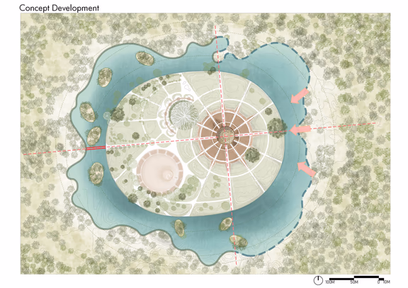
Proposal by Mohan Rao, based on The Mother’s description of the Matrimandir lake, with maximum four meters depth and natural seasonal variations
The task force consulted Mr. Mohan Rao, a critically acclaimed Indian landscape planner and architect, to ask him if it was possible to make a lake with such a brief. He prepared a preliminary design concept that demonstrates it is not only possible but it can be beautiful, too. The design was presented recently to the community in a five minutes video.
Auroville Today asked a member of the task force, Suhasini, to tell us more about the background and why an alternative concept is necessary.
Auroville Today: Why is there a need for an alternative design for the lake?
Suhasini: The Matrimandir lake is situated on top of a plateau that impacts three watersheds carved out over millions of years. So when you interfere with a watershed, which the present design would do by creating an inverted dam of 100 metres width and 10 metres deep, you need to be very sure about what you are doing and its possible consequences, not just for Auroville but also the wider region.
The Mother’s vision calls for a lake around Matrimandir and its gardens. About decade or so ago while walking round the Matrimandir gardens with Mohan Rao, a landscape planner specialized in watershed planning, I asked him about the feasibility of a lake around the Matrimandir, sitting on top of three watersheds, and he said it was possible, but one had to be creative. He also pointed out that often around or near religious structure in India there is a water body, as water is an interface between spirit and matter.
In 2013, Aurovilian Gilles Boulicot published a report “A study exploring a multi-sourcing approach for Auroville with the integration of Matrimandir Lake.” This study was commissioned by the Auroville Town Development Council. I thought this study held the key to the possibility of doing a water body around the Matrimandir that would be the least intrusive way to fulfill the vision. A few years before that, Michael Bonke’s team had started to work on six mini test ponds to ascertain the best sealant, evaporation parameters and construction methodology. And I imagined these studies would be complementary.
But the study made by Gilles was never discussed or considered by the team working with Micheal Bonke, and this was a huge loss. Meanwhile, Michael’s team decided to undertake implementation of a test lake of approximately 125 x 100 m in size and a depth of 10 m.
I was sitting on the sidelines and observing all this. Suddenly, last year Michael’s team commenced a rapid ground clearing around the Matrimandir gardens, cutting the large trees indiscriminately. This action was traumatic for the residents given the recent history with the Crown Road development. Who in this day and age cuts down trees on top of a watershed? Is it not possible to develop Auroville without destruction? Why are we adopting the conventional mode of development by destruction?
But, still, I didn’t get involved. However, when I went to Michael’s second presentation, I realized that here was somebody who lacked the capacity to comprehend the complexity of the project but as he was the channel for the finance, he appointed himself as the client, project manager and techno-feasibility expert. Moreover, he was also setting the timeline for the implementation.
This is what most developers do as they see development projects as financial investment: the faster the development is done, the lower the cost of investment considering inflation and interest rates. But with infrastructure, commercial, institutional or residential development projects, there are precedents that allow a developer to assess risks from unforeseen events and account for it. But in our case, we don’t have any case studies or a precedent. Is there a lake on a hill anywhere in peninsular India? Is there any geological study of an island with a completely sealed moat around on top of a hill? Any data on how water that cannot percolate or diffuse laterally because of a sealed moat will impact structures due to water logging?
I felt it is our responsibility to tap the knowledge pool we have in Auroville and evaluate the risks involved. So, after his second presentation, a few of us met with Michael. I had prepared a short note from the six mini test ponds and the annexure to the site application made for the test lake to gather information on the data collected and analysis. It was in this meeting we got to know that, out of the ten parameters that they had listed in their site permission proposal, only four were investigated, all of them pertaining to the HDPE sheets as sealant. No data has been collected on the lake stratification (temperatures at various depths), water quality, sedimentation and more. When we suggested that this should be done before going forward with excavation, Michael dismissed the need for more data as he had employed experts in Germany and they were of the same opinion as him. The fact that both his German experts and Harald Kraft’s experience with constructing water bodies is primarily in temperate zones, was not important.
We admitted we were not experts; to get out of the impasse we proposed a third party evaluation with independent experts, one with a background in tropical climate appointed by us and an expert appointed by him and together they select a third expert. The three would study and evaluate the lake design including the size, depth and water quality and give us their recommendations. I thought this was a very reasonable proposal, and it wouldn’t need to take long, but Michael was furious and accused us of having blocked the development of the lake for many years.
I’m not questioning the vision; I’m questioning our capacity to make decisions that will impact not only Auroville, but also the bioregion. When people are overwhelmed by complexities of systems and processes beyond their capacity, the tendency is to fall back on received wisdom and belief systems. And invariably the consequences are disastrous. So many unconscious acts have led to irreversible damage to entire communities and ecosystems.
But Michael’s team would say they are looking at the future because they are creating a reservoir to provide water to the township in an emergency.
The lake must be 10 meters deep to accommodate the submerged HDPE balloons filled with potable water holding one month’s supply of water for the township of Auroville. This is looking at the future? Let us unpack this claim. Considering that most of the area is dependent on ground water, failure of this resource will be due to over exploitation, leading to salinity due to sea water intrusion. In such a case, having a one-month buffer is supposed to be sufficient time to find and tap into another source? And as Michael has promised that no ground water will be used either to fill the lake or the balloons, he is assuming a desalination plant will be up and running shortly. In that case, why pump the desalinated water into the balloons, wait a month till they have been emptied and then connect to the desalinated water pipe to distribution network to supply the city of Auroville?
Their other justification for the depth, apart from more efficient evaporative loss, is that it’s required for water quality.
Was regular water quality testing done in the test lake and compared with water from ponds of four meters or less deep to show that the deeper water body had better water quality? Similarly, was the evaporative loss monitored in the test lake and compared with the standard published data for evaporation in the zone? If not, what is the basis of the justification?
Michael said that a current would ensure that a dead, de-oxygenated zone would not exist at the bottom because the water would be continually re-circulated.
Temperature and density are inversely proportionate, which means that warm water will remain on the top and colder below. What will cause a current to reverse this? A breeze will ripple the surface water, move it forward till it reaches a barrier where it will break. But energy released by breaking of these ripples or waves is insufficient to push the warm water down to churn up the colder water.
If you take the ocean currents like the Gulf Stream, the warm water is pulled towards the north pole to replace the sinking freezing waters in the arctic circle. So, unless we also create a system of freezing water to sink to the bottom, the warm water is going to stay where it is.
As I see it, the majority of the community agrees on very simple criteria for the lake. It needs to be a living water body, which means incorporating aquatic flora and fauna that will have a self-regulating capacity to fix oxygen and break down the organic matter. And the lake should be rain-fed; and the shoreline landscaped to tolerate the seasonal level fluctuation. Just these three basic criteria. If, over and above that, it provides water for the Matrimandir gardens and supplies water to the city, that would be great! But not at the cost of these three basic criteria.
The Matrimandir Task Force was formed to come up with a design brief based on parameters that elaborates these three criteria. And the alternative concept design presented by Mohan Rao based on this brief is a concept and a direction. It will need to be elaborated. But all we wanted at this point was to know that it is possible, and it seems it is.
As there is a lack of supporting data in the public domain for technical claims made by Michael and his team, the only way forward is a third party independent review of their design and techno-feasibility study by experts. And if his technical experts have the proof of concept, they should be more than pleased to have it peer reviewed.