The Darkali Water Catchments: Integral Features of Eco-Intelligent Urban Park
FeatureBy Gita
Keywords: Darkali forest park, Ecological restoration, Management, Crown controversy, Mahasaraswati Park, Darkali canyon, Crown Road and Right of Ways (RoW)
Darkali Water Catchment
After the first year, using the money Gopal got from selling his guitar, they dug a borewell, installed a hand pump, plonked three simple cots on the site, and began living on the land in what is now known as Darkali Forest. Each time Auroville acquired more lands in the vicinity of the future park, the Darkali fences would be repositioned along the new boundary. For the first 15 years, the stewards “basically worked every day with the limited tools and means we had…to bund the whole place and to slowly start a bit of water catchment.” Through increasingly intricate bunding and landscape features, enough water was held on the land to nourish the growing trees through the dry season.
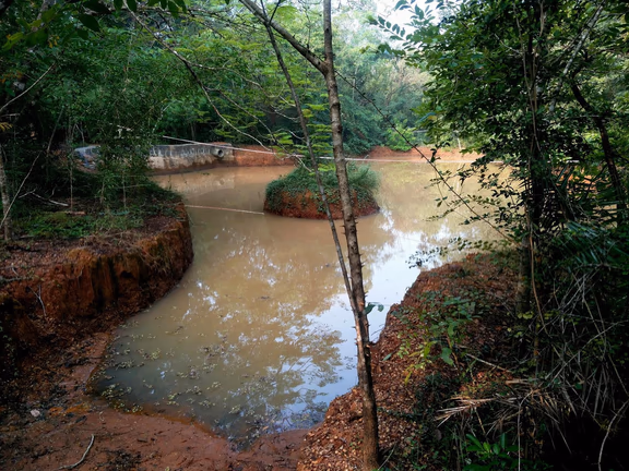
Darkali Canyon
But gaining access to the canyon was the game-changer. When Auroville purchased the plots adjacent to the canyon (located on poramboke, or unclassified public land), it suddenly became possible for the stewards to envision water harvesting and ground water recharge on a much larger scale.
The land on the west side of Auroville slopes from two directions (east and south) to form a major gully at the Darkali canyon. According to Prashant Hedao, a resident GIS expert, the water from more than 60% of the area inside the Auroville Crown drains through Darkali during the monsoons. While the canyon is not extremely deep, it is long. The canyon’s overflow travels behind Kottakarai, out through Alankuppam and connects finally to the Kaliveli wetlands 10 kilometres north of Auroville. Technical reports and water strategy recommendations stress that this is a sensitive area for water catchment and recharge strategies, both for Auroville and the sub-watershed (covering approximately 135 sq. km.).
The stewards began constructing earth dams in the canyon at key points using, says Gopal, their “tiny, little means” and every year building “a little higher, a little stronger, a little better.” They made bunds and planted around the canyon to stop erosion.
From 1991, a Tamil Nadu rain water harvesting scheme began making funds available for check dams in key locations. At some point, a government contractor arrived and announced that he was to make some small stone dams in the canyon. The quality of the work was such that these dams fell apart within a few years. Still, two good things came of the experience: government recognition of Darkali’s potential as a water harvesting area, and a treasure trove of free stones that the stewards could now reuse to build solid spillways for earthen dams. The stewards subsequently built three major dams and two minor ones with the re-purposed stones, and they deepened the water catchment areas upstream of the dams. But there was one last, most important dam that kept getting washed away. The topography was complicated, and there was too much sand underneath the structure.
Bobcat in Darkali
When a bobcat mini excavator was acquired about 15 years ago, Darkali was finally able to dig its way out of previous difficulties. The stewards started with the existing dams and catchment ponds, increasing height, width, and area. For the fourth major dam, they dug out all of the sand, started with a proper earth foundation, and then built the dam up layer by layer. A huge water catchment area was excavated.
From the forested park down to the canyon, rainwater run-off is now slowed by a virtual maze of aesthetic landscape features. The overflow from each feature is guided into another area, and another, until all of the water is guided into the catchment area of the fourth dam. On an average year with 1.4 metres of rainfall, Darkali sees almost zero runoff from its 50 acres, and an estimated 4 million litres of water are harvested.
Park Boundaries
Before Auroville architect Roger Anger passed away, he had agreed with the Darkali stewards on an updated Galaxy concept Plan that enlarged the boundaries of the designated green area. Gopal explains that in the previous version, this was “too small a strip for a meaningful park” and ended 50 metres before the canyon. The new boundaries, including the canyon, were finalized on paper by the Town Planning group of the time, and officially signed in 2009.
Crown Road and Right of Way
Over the years, there have been multiple markings and surveys for the Crown Road. Darkali’s stewards have regularly sought clear indications of where the road would pass, and have kept the dedicated strip of land free of major plantation in order to accommodate it. In 2012, the Technical Design Study of the Crown Road (commissioned by Auroville) plainly stated the need for an Environmental Impact Assessment of sensitive areas – defined as canyons, water recharge areas, and Bliss / Darkali Forests – along the road’s projected path. This has yet to be done.
Amidst the recent initiative to kickstart Auroville’s stalled urban infrastructure development, the projected Right of Way (ROW) for the Crown Road was newly mapped as a 16.7 metre wide, perfectly circular corridor. In Darkali, this would mean ploughing straight through and filling in the largest, most important water harvesting structures, as well as clearing and eventually paving over much of the intended park area. Darkali’s stewards have proposed a 2 metre shift back to the strip of land previously marked, which would still keep the route within the overall 30 metre ROW and would safely preserve the water harvesting structures and capacity. Since this section of the road would pass through a forested park, the width of the road together with a single infrastructure corridor could reasonably be kept at seven metres.
Ignoring this proposal, the long pending environmental assessment, and the need for official notice, bulldozers were sent to Darkali on 9 December to begin clearing the ROW. A significant number of trees were destroyed before a Stay Order from the National Green Tribunal came into effect on the afternoon of 10 December. But the water catchments are so far still intact, still full of precious water, and slowly allowing that water to percolate into the soil for the benefit of this entire bioregion.
Many of Auroville’s residents are newly hopeful that these recent events will ultimately open up a different way forward, one where ecologically important areas like Darkali can be intelligently and sensitively incorporated into the urban fabric. Isn’t that just the kind of city the Earth needs?