The Art and Craft of Catching Water in Auroville
FeatureBy Gita
Keywords: Water management, Kaluveli wetland / Kaliveli watershed, Water catchment / harvesting, Rainwater harvesting, Ecological restoration and GIS (Geographic Information System)
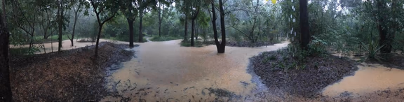
Darkali water catchment
Through trial and much error, new arrivals to the denuded plateau learned that planting and tending to saplings was not enough. Given the natural slope of the land, the soil and plants would all wash away in the course of just one intense rain. The canyons in and around Auroville were deep wounds in the land, bleeding red soil into the sea. To best retain water and stop erosion, work had to start at the very top of the slope. Soil bunds, or embankments, had to be sculpted along the contours of the land and stabilized with vegetation. But the land can only absorb so much water at a time, so ponds of different sizes had to be dug at strategic points downhill. As one pond fills, water is channeled to the next, and the next. The long, deep canyons at the bottom have – over decades – been transformed by Aurovilians into large catchment areas through check dams of various sizes. To Auroville’s east, the goal is to stop rainwater from running off to the sea. To the west, the water is channeled into the pre-existing village tanks. And as this water percolates, ground water is slowly recharged.
After 53 years, there is still much work to be done in the city area to systematically ensure zero surface water run-off. In 2021, close to three metres of rain fell in Auroville, more than twice the annual average, and most of it over a short period of time. The canyons could not contain the additional volume. Before the rains had even ended, Kireet – Auroville’s de facto pond landscaping expert – began receiving calls for advice from communities in low-lying areas where homes and roads had been flooded.
Until now, it has largely been left to individual land stewards to figure out what needed to be done to manage surface water, and to find the financial and technical resources to do it. Kireet has personally planned and overseen water harvesting structures in Utility, Aspiration, and Auromodele Canyons; hundreds of new catchments in other communities; and desilting or improvements in countless ponds. Auroville units Harvest and Palmyra have also rehabilitated a number of village water tanks and channels in the bio-region. But this is just not enough.
Over the last twenty five years, numerous studies and reports published by, for, and in collaboration with Auroville have all sounded increasingly urgent alarms. Comprehensive strategy and integrated water management systems are crucial for water security in Auroville and the bio-region, with catchment ponds highlighted as an essential component of a holistic system.
The immediate threats are multiple. Exponential population growth and irrigated agriculture in the area have led to massive over-exploitation of groundwater resources. Referring only to Auroville and its immediate surroundings, Auroville’s Prashant Hedao (GIS specialist) estimates ground water usage is roughly 30 times what is recharged. The depleted aquifers are in immediate danger of salt water intrusion, both from the sea and from older, deeper aquifers. There is constant risk of water contamination due to agricultural fertilisers and pesticides, construction, and a dense population with inadequate sewage systems. Extreme weather conditions – including flood, drought, and deadly heat – now seem to occur at regular intervals.
In this water-stressed context, which is echoed across Tamil Nadu, every water body is an asset. The Madras High Court has, in several 2021 rulings, repeatedly directed the Tamil Nadu Government to protect existing water bodies, along with forests, “so that future generations find the state habitable and can survive here.” In response, the Tamil Nadu Registration Department has issued a registration ban to prevent encroachment and development on existing “waterbodies, waterways, water catchment areas, and associated Government parembole [unclassified] lands.”
Recent news and events seem to indicate that Auroville has arrived at a potential turning point in its physical development as a city. Perhaps this is also a very real opportunity to create a working model for protecting water catchments and catchment areas as part of a holistic water management strategy for the city and bio-region, within a holistic development framework.