The Town Development Council on the Crown, mobility and participative planning
An interview with Auroville Town Development Council (ATDC)By Editors
Keywords: Auroville Town Development Council (ATDC) / L’Avenir d’Auroville, Crown Road, Master Plan (Perspective 2025), Outer Ring Road, Four Zones and Roads
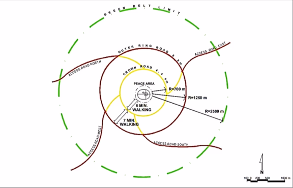
The Outer Ring Road (brown circle) with four access roads is planned between the City area and the Greenbelt. The Crown Road and its four access radials are marked in yellow
What is the conception of the Crown? Is it simply a communication channel between the four zones, or something more?
It is more. It is envisaged as the spine of the city comprising important buildings catering to the four zones, as a place of contact, connection and get together for the residents and guests, and as a channel for efficient infrastructure and mobility.
Should the Crown/overall plans take account of ground realities, like existing natural features and habitations, people’s homes, villages etc.? If so, how?
Yes, with surveys, mapping and consultation with local residents of the community and stewards of the lands.
What is the urgency to manifest the Crown now, before there is a proper mobility plan, before all the land is bought, and before the whole community is in agreement about the process?
Fifty three years have passed by without much progress in the physical manifestation of the city. The Auroville Master Plan was gazetted in 2010 and numerous studies have been conducted regarding the same. The Crown being a fundamental component of the Galaxy, without manifesting the Crown the city cannot be manifested. The physical manifestation of the city is imperative to protect Auroville from outside suburban sprawl and the threat to our natural resources.
How do you envisage mobility inside the city in view of the increasing number of Auroville residents, 7000 Auroville employees, Auroville guests, construction traffic and visitors to Auroville units and individuals, including courier services?
Reducing individual transport and encouraging shared transport within the city is one of the key features of the mobility proposal. Embracing collectivism, a shift in mindset and behavioural change towards mobility within the community and its surroundings are needed to make Auroville a livable city. The city is envisaged as pedestrian and bicycle friendly, with shared non-polluting public transport, scheduled service vehicles and emergency vehicles to maintain the overall sanctity of the environment.
How do you envisage the mobility to reach Auroville, in view of the above (village workers, guests) and the increasing number of people who visit Auroville as day-tourists?
A mobility plan which includes policies, logistics and temporary arrangements is currently under development, in line with the broader mobility proposal of a car-free city. There are numerous mobility plans that have been worked on in the past by experts. The proposed plan shall also incorporate the relevant outcomes and details from those. The mobility plan shall take into consideration all types of present and possible future users that will commute within and outside of Auroville.
How is the outer ring road planned? Will all traffic be permitted to travel on it – if it’s open to anyone, won’t it turn into another highway and bring highway problems (noise pollution, environmental pollution, build-up on road etc.) and badly impact two villages which it would pass through, as well as the greenbelt, which it would separate from the city?
For the very reason that the outer ring road passes through adjoining villages, it is important that it remains public and accessible to all. This road will receive traffic from the access roads that would connect the Pondicherry-Tindivanam Highway and the East Coast Road. The main purpose of this road in the context of Auroville is (1) to connect the four zones on the peripheral side of the city (2) to divert the non-Auroville bound traffic from entering the city.
Are you in favour of participatory planning for the city area? If so, what, practically, do you understand by participatory planning? There have been other studies done – those by Doshi, Suhasini, David, Prashant etc. – which include the social, environmental, economic, political, regional aspects which are supposed to be incorporated into the town planning. Are you going to incorporate these?
Yes. We are conducting design workshops with the community, we are in the process of reviving the dream weaving process with the architects of Auroville, and simultaneously we are in communication with Mr. Doshi. We acknowledge that numerous studies have been made both by Aurovilians and outside experts, and synthesising them to the current context and ensuring those that are relevant, especially those that fit within the overall vision of the Galaxy, Auroville Charter and the Gazetted Master Plan, is the need of the hour.
What competence do you think is required to plan Auroville? Does Auroville possess people with such competence? If so, how can they be utilised effectively?
Understanding of the Mother’s vision of Auroville, understanding of the Charter, competence in urban planning and design, architecture, knowledge of our community’s complex history and diversity, fundraising to build the city, buy the lands, skills in communication and community process, are some of the main competencies required to plan Auroville. Auroville does have the required competency and, wherever required, the skill set and consultation could be sought from outside. The experience, knowledge and goodwill of the community can be tapped through workshops and consultations, in the belief that we as residents are stewards of this project and are here to manifest Auroville, the city of the future. These also require enormous behavioural changes from all of us.