An alternative approach to planning
An interview with SuhasiniBy Alan
Keywords: Auroville Town Development Council (ATDC) / L’Avenir d’Auroville, Detailed Development Plans (DDPs), Auroservice d’Auroville, Master Plan (Perspective 2025), Residential Zone and Private lands
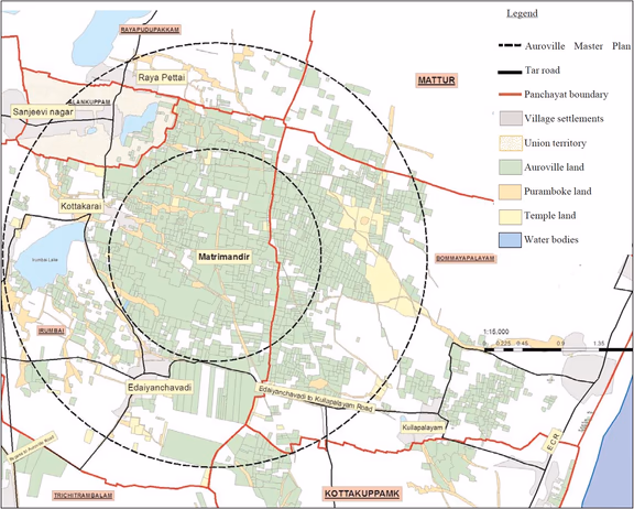
Approximate map of Auroville and the surrounding areas. In green are all the lands owned by Auroville. In the inner circle, the city area, most lands are owned by Auroville, but this is not the case in the outer circle, the Greenbelt
Suhasini
Auroville Today: What led you to do this latest study?
Suhasini: To answer this I need to tell you a little bit of personal history. I came to Auroville in the 1980s as an architecture student. As I intended to study town planning after architecture, my plan was to intern at Auroservice d’Auroville in Pondicherry, one of the rare non-governmental agencies doing town planning in those days. Till the mid 90’s town planning and development was done almost exclusively by the government. Due to a variety of reasons, I eventually interned with Poppo in Auroville. With not much to do in the studio during the internship, I explored Auroville to understand what it was all about. I started speaking to people, reading old publications and a few books on or by Mother and Sri Aurobindo.
This led me to do my undergraduate thesis on Auroville’s town plan. The thesis had three parts to it. One was the philosophical basis behind Auroville, with Kireet Joshi as the advisor, the second part was the physical aspect of the plan, for which I interviewed Roger Anger, the chief architect. The third part dealt with the socio-economic and cultural aspects of such a development in this particular context – Prof: K T Ravindran was my advisor for this – for I was very concerned about the socio-economic impact of developing a city as depicted by the Galaxy concept in the regional context that existed in the mid-80’s around Auroville.
In other words, I realized during this study that there was a huge gap between the normative and predictive planning components in Auroville. For some of the normative part, comprising Auroville’s values and ethics, drawing upon the Charter, Mother’s vision etc., content was available, but integration of other normative values, like environmental accountability and sustainability, social equity, unity and harmony, was neglected. And the predictive part, which involves evaluating future needs based on analysis of development of the last decades to arrive at quantitative goals, was completely lacking. The normative part gives us the qualitative goals to set directions with a road map and the predictive part allows for quantification with milestones. These two aspects must work together for effective planning and development.
I didn’t spend much time on the normative part of Mother’s inputs on Auroville as Gilles Guigan was researching this and sharing his work with many of us. I was more interested in the physical and human aspects. In 1985, a Canadian couple facilitated the setting up of the Auroville Resource Centre. For about three years a group of Aurovilians worked to evolve an integrated planning approach, which would include introducing environmental and social aspects into the Galaxy concept. However, in 1988 Roger and his team took over the planning office and we were marginalized as our approaches diverged from theirs and there was no room for divergent viewpoints. I was disheartened, and withdrew.
But at some point you resumed the work.
Yes. In 1999, Roger’s team started working on the Auroville Master Plan Perspective 2025, with support from the Asia Urbs project, focusing mainly upon the descriptive or the formal aspect of the town. This 25-year Master Plan was marginalizing the context – the physical and human geography – thus relegating the whole attempt into a theoretical exercise. Because unless you know where you are now, you don’t know how to get to where you want to go.
In the mid-90’s, I got a scholarship for a two-year programme on environment and development studies, focusing on environmental – economic – political scenarios in Southern Africa, Central America and India. The two-year course empowered me with knowledge and skills to revisit the planning process for Auroville. I proposed to L’Avenir d’Auroville, or TDC as it was called in 2013, to make a land suitability analysis of the city, which meant overlaying the Galaxy concept with the physical geography, such as land holdings, topography, climate and ecosystem services.
In this study we identified about a dozen spots where there would be a conflict between the ground reality and Galaxy concept, but all could be resolved with timely adaptations. I also looked into the question, “Is it possible for the city to have sufficient open spaces to house a 50,000 resident population without the lines of force?”
Scenario 1, an extreme case, had the following baseline parameters:
1. Most of the existing settlements in the Residential Zone are not inclined to accept more development unless it follows a participatory model
2. Privately owned land in the Residential Zone is not for sale due to issues of ownership, sale value and/or sale to outside agencies who value the proximity to Auroville
3. A population growth rate of 4% per annum
4. Lack of sufficient capital investment from the economic sector to finance housing
5. Only low-rise walk-up buildings of ground + 3 floors with low-impact development, with permissible ground coverage ranging from low (20%) to medium (30%) with minimum pockets of high (50%) density, at 38 m2 per person.
With these preconditions, we could accommodate 18,000 persons in the Residential Zone, along with all the physical and social infrastructure required. At a 4% growth rate, Auroville would have a population of 5,000 by 2028, and the additional 1500+ could be accommodated in sectors 1 & 2 without having to change any of the parameters outlined above.
Scenario 2 had the following baseline parameters:
1. All the existing settlements in the Residential Zone are open to additional development within reason.
2. All the privately owned land in the Residential Zone has been bought before the end of 2015.
3. A population growth rate of 10% per annum
4. Public capital is no issue and livelihood options create a socio-economic climate permitting public housing projects for free occupation by the residents, according to their needs and personal situation.
5. Only low-rise walk-up buildings of ground + 3 floors with low-impact development, with permissible ground coverage* ranging from low (20%) to medium (30%) with minimum pockets of high (50%) density, at 38 m2 per person.
With these preconditions, one can accommodate 35,000 persons in the Residential Zone, along with all the physical and social infrastructure required. With a 10% growth rate, we would have a population of about 13,000 in 2028 and this population could be accommodated in sectors 1 to 3 within the outlined parameters.
Both scenarios demonstrate that the tweaking of the Master Plan 2025 to ensure the sustainability of the project does not in any way negate the form or population capacity of the Galaxy concept. In June 2014, I submitted the final draft report to the TDC for discussion, before undertaking presentations to the community for feedback. But discussion was not possible as some members in the TDC rejected it.
Why?
They felt overwrought by the very idea of a land suitability analysis for a divinely ordained town. But there’s a larger issue here. There’s a theory of planning called Urban Regime Theory. This holds that in certain places the community leadership uses a certain framework, or regime, for examining issues.
Individuals or interest groups who argue from outside that regime will find it very difficult or even impossible to win decisions. In Auroville, the Galaxy group acts as the shadow planning body, and as they equate the Galaxy plan with the Auroville Charter, it is inviolate. For just as none of us would dream of rewriting the Charter, it effectively means that there can be no contextual adaptation or interpretations of the Galaxy. Any proposal that proposes adaptation responding to the physical and human geography is therefore unacceptable.
The sectarian politics of planning in Auroville can be very discouraging, but after doing the land suitability analysis, I felt I had to study Auroville’s development pattern to understand the gaps and challenges.
Which is what led you to the latest study.
Yes. We decided to study the output of Auroville development for the period 2008 - 2018 in three areas: the overall economy, the physical infrastructure, and the social infrastructure in comparison to resident population growth and demographics. In these three areas, we studied five sectors: water/energy, health, education, housing and economy. We collected secondary data from various working groups, units, trusts, services, the annual reports of the Auroville Foundation, and primary data, using questionnaires and interviews. With the output of the analysis, we set about identifying the development priorities that could meet the projected population growth for the next decade 2019-2028 for three different growth rates. We then organized consultative meetings with a focus group of informed individuals and all the relevant working groups and individuals to get their inputs in order to frame the policies, programmes and projects. These were then evaluated in a comparative matrix to identify the critical policies and programmes needed to meet the developmental needs for the next decade.
What were the most important findings?
One of the main findings was the lack of any structure for integrated data collection and management to have the comprehensive and accurate information needed for governance, administration and planning. At present, all sectors function in silos and are territorial with their resources. And people with capacity refrain from engaging in the public domain, either because they will find it a waste of time or because they will be publicly vilified for their efforts.
Analysis of the 2008-18 figures also revealed a lack of coherent policy planning linking Auroville’s economic development to the development of its physical and social infrastructure. In other words, the present development modality is ad hoc, so the parts do not plug in together to create a greater whole.
But what was causing this? Was it a lack of human or financial resources?
No. The study shows that it is a systemic issue. The structural framework in place is preventing us from maximising our capacity. Our governance structure is self-defeating as it is creating mistrust between the residents and the working groups. The way the mandates of the major working groups are written ensures insularity. The working groups are appointed to administer decisions of the Residents Assembly, but due to a lack of any unified policy making body, they are obliged to formulate hurried regulatory mechanisms to deal with crises, rather than as an output of a long-term vision. Moreover, these regulations do not relate to each other: in some cases, if you follow one, you could be violating another.
One example of this is how we regulate our economy. The commercial sector is meant to finance the public or service sector. However, the trend shows fewer residents are being employed in the commercial sector compared to the public / service sector, so the FAMC and BCC is constantly chasing after the 33% contribution on profits of the commercial units to pay for the city services’ budgets. Besides the non-acknowledgement of the diversity of enterprises and differences in their production and profit cycles, this discourages start-ups and causes stagnation of small and medium sized units, as there is insufficient capital to invest in skill development, growth or diversification.
Having said this, one of the amazing things we found in our survey was, even though there is not any kind of convergence of the regulations in the sectors studied, somehow the muddling through approach has not done too much damage. In fact, in some areas the present development could accommodate the doubling of our population. However, we will need targeted policies to coordinate the areas that are deficient if the needs of the projected population are to be met.
So how do you change the system in order to facilitate better development?
We need development, but not in the way we have been developing so far, which has been essentially through ad hoc projects that do not relate to each other. Presently Auroville is a mosaic of agencies and institutions. In order for them to function together would need active collaboration. This could happen if there was a convergence in terms of programmes, with decisions taken within a unified policy planning framework. But to undertake unified policy planning we need reliable data.
The effective way to initiate and manage this change would be to identify mid-term goals for a target population, based on a growth rate that is in sync with our carrying capacity, and undertake policy planning that would provide a framework to roll out programmes embedding the development projects needed to meet this growth.
Essentially the five main working groups (Entry Board, Working Committee, FAMC, TDC and the Auroville Council) have to come together and set up a policy planning body which looks at all existing mandates and regulations to bring convergence of policies, and this needs to be backed up with a reliable data management system for an accountable administration and an informed decision-making process. The data would give the quantitative goals while the programmes give the direction. These two must work together in a way that permits adaptation to new information, knowledge and changing circumstances. This is why it would be counterproductive to have policies that are too long term or overarching, as they become an impediment to the very thing they were set up to enable.I would not propose a sweeping change; this would cause regression and reactions that would entrench us in the ongoing conflicts. While the coordinated data collection and policies planning institutions need to be set up, some of the existing structures can be used to progress. In May 2017, the Residents Assembly ratified the planning principles. These could provide the baseline for a proposed land use for the Master Plan area and a Detailed Development Plan that is evidence based, and that responds to gaps and challenges in the present development while meeting the needs of the next decade.
This study is the first step towards demonstrating the need for a unified policy planning body to ensure convergence between the policies of the various working groups, along with evidence-based planning to predict, plan and guide the development of Auroville.