Mini test ponds for the Matrimandir Lake
FeatureBy Carel
Keywords: Matrimandir Lake, Water, Desalination plant / technology, High density polyethylene (HDPE), Germany, Naue, Anna University, Chennai, Ecological biodiversity, Artificial hill, Desalination plant, Matrimandir Coordination Group and Water management
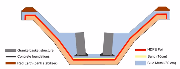
cross section of a mini test pond
The lake around the Matrimandir was foreseen by The Mother. Already in 1965, years before Auroville was founded, She had given Nata the task of studying the lake and how the water could be sourced. Nata’s research assumes a 100,000 square metres lake area and mentions desalinated water, not only for filling the lake, but also for drinking water purposes. As he wrote to Mother on 31st October 1965, “There exists also the possibility, envisaged by you, Mother, to have drinking water through the process of desalination of sea water.” Desalination, in those days, was just in its beginning phase.
Since then, the Lake has been a topic of study and dispute. [See AVToday # 259, January 2011.] Last year, a self-appointed Lake Team took matters in hand. It executed a number of drillings in the area of the future lake, to ascertain the underground structure. [See AVToday # 290, September 2013]. Now, the team have started digging mini test ponds. Auroville Today talked to Michael Bonke, who is one of the moving forces behind this latest initiative.
Auroville Today. What are the objectives of the test ponds and when will they be ready?
Michael: We are constructing six mini test ponds, approximately 15 x 15 metres each and 1.5 metres deep, which will hopefully be ready before the beginning of the monsoon. The purpose of the exercise is to compare four different sealants and two different methods of how to construct the bank. The comparison is not only aiming at finding out which sealant is technically the best, but also to learn what costs are involved, how difficult the sourcing of the sealing materials is, and how easy it is to work with them.
The sealants we will be testing are natural clay from the Auroville surrounding area; compacted clay provided by a specialised company in Germany; 2 mm thick high density polyethylene (HDPE) foil manufactured by the German firm of Naue; and bentonite mats. These mats consist of two layers of geofabric with bentonite – the swelling component of natural clay – in between.
We have already run into difficulties with some of the proposed sealants. Sourcing the huge quantity of natural clay required from the Auroville surrounding areas has proven to be difficult, if not impossible. The clay we found so far does not have a uniform consistency and that makes it unsuitable for our purpose. Compacted clay seems better, but the costs of sending and importing it are prohibitive. We have even studied if we could set up a plant in Auroville to make the compacted clay ourselves, but that doesn’t seem feasible. It is not only a costly affair, but also the raw materials would have to come from the surrounding area and this clay is not good enough, not even for compacting. Regarding bentonite, we again face high costs importing the huge quantity of mats required. So these options are increasingly unlikely.
We have also to keep in mind that the earth in the Auroville area is not stable. It moves, as can be deduced from the cracks in many Auroville houses. When we inspected lakes in the surrounding area, we noticed that some lake beds also have large cracks, even up to 5 centimetres wide. A sealant like clay would not close such gaps. So this seems to leave HDPE foil as the best solution, and we are thinking of foil that is 2 mm thick.
But all this is still not decided. The proof will be when we test the materials in the ponds. For each material we will get technical support from the manufacturer, who will teach us how to work with the materials.
Four of the six test ponds have gentle slopes. But in two ponds we will use foil and bentonite mats to test the possibility of making vertical banks or step-banks. This would be done with stone gabions with the sealant being more or less vertical behind the gabions. Vertical banks may be required for architectural reasons and also around the pillars of a bridge, or at an overflow or inflow area.
How will you test for leakages?
There are several ways. On is to install humidity sensors underneath the sealant. Another one is to make collecting channels below the sealant with a sump on the shore. If you see that the sump gets filled, you know there is a leak. This could work when we use HDPE foil or Bentonite mats.
So a few months after the monsoon, you will know what materials to use?
Yes. We will then know which solution is the best. But this will not be the end of the matter: the test ponds will only be 1.5 metres deep, while the Lake is envisaged to have different depths, up to 10 metres. Specialists from the Anna University in Chennai have advised to create a test lake of 10% of the final lake area. We plan to make this test lake 10 metres deep. This will show how the sealant behaves at this depth, if it expands or contracts and what happens when there is an earth movement. This test will be over a period of one to two years.
What about the final depth of the lake?
This is still being studied. Some say that making the lake deeper than 4 metres does not have any practical advantage. Others say, the deeper the lake, the better the water quality. My personal preference would be a lake with many varying depths. This would lead to richer biodiversity.
The lake will naturally attract a lot of wildlife. Fish, turtles, frogs, they all will be there, as well as water birds. But we need to ensure that the water quality is as clean as possible. In this climate, algae proliferate, and a green soup around the Matrimandir is not so nice. We’ll also need to study which water plants will be most suitable. Some plants may help clean the water, some may reduce the lake’s water evaporation, others may increase it.
What do you propose to do with the earth which is dug out to create the Lake?
We want to make a hill with it in the northern Greenbelt. This will create an additional and very valuable recreation possibility for Auroville – you can go up the hill and watch the sunset. The earth would be transported there by conveyor belts, laid in trenches inside the earth. So there would be minimal pollution from trucks. Trucks would only be used to transport the earth from where it is dug to the conveyor belt, and again, from the end of the conveyor belt uphill.
We are also planning two more lakes: one next to the hill, and another one on top of the hill. Both could be used for recreational purposes. But the lake on top is primarily intended to be used as an uphill power storage, where it would interact with a lake at a lower level and so provide electricity to Auroville in times of power cuts. [see AVToday # 271, February 2012]
The purpose of the lake next to the hill is to be a buffer lake for the Matrimandir Lake. Roger Anger was very adamant that the water level of the Matrimandir Lake should remain the same in all seasons. This is not possible without a secondary storage lake which can feed the main lake. The fluctuation will then happen in the storage lake, not in the Matrimandir Lake. The earth dug to create this second lake will also be used to increase the size of the hill. And the trenches for the conveyor belts will, after the hill has been created, become open water ways to connect this second lake with the Matrimandir Lake.
This brings us to the question of how the Matrimandir Lake is going to be filled.
For the first filling of the lake, we plan to use desalinated water. We cannot use groundwater. We hope to be able to build a desalination plant on the beach within three or four years from now, which initially will be used to fill up the Lake. With a production capacity of 1 million litres of desalinated water a day, a varying lake depth and a lake surface of 162,000 square meters, filling the lake might take up to 2 years, without calculating the inflow of monsoon rains and the water losses due to evaporation.
Once the Lake has been filled, we will need to keep it at the same level. Calculating an average yearly rainfall of 1.30 metres and an evaporation of 1.70 metres, this would mean 40 cm loss over a year. This comes to 64,000 cubic metres a year, or 175 cubic metres a day. If we assume 250 cubic metres loss a day, we have a figure that is equal to the present-day water requirement for the Matrimandir gardens. In other words, it is a manageable figure. These figures, of course, are yearly averages. In the summer season we will have to add more water to the Lake than earlier in the year.
This additional water would come from the buffer lake. This buffer lake would be filled with harvested rainwater, e.g the rainwater falling on the buffer lake itself, the runoff rainwater from the hill and the run-off rainwater from the lake’s surrounding area.
Another source for the buffer lake will be the excess water pumped from the Matrimandir Lake. During the monsoon, the Matrimandir Lake would overflow as it will collect rainwater falling on it directly, the rainwater run-off from the Matrimandir Oval, and the rainwater run-off from the outlying southern and eastern areas which are higher than the lake. The Oval alone, it has been calculated, can provide 40,000 cubic metres run-off every year because large parts are paved, such as the amphitheatre. Today, the water that falls on the amphitheatre runs off into the Kottakarai canyon and is lost. Once the Lake is there, this will no longer be the case.
You mention the Lake’s surface area as being 162,000 square meters. This is the size decided by Roger Anger. But over the years, there have been many serious disputes about the size, even involving a mediation attempt by the Governing Board. Has this dispute been settled in favour of the large lake?
The reason for the dispute was that the then Matrimandir Coordination Group was concerned that by creating a large lake, the existing outer gardens and the whole concept of the Mother of the outer gardens would disappear. This is why they were in favour of a smaller lake. The issue has never been resolved, but I think that it is possible to combine a fairly big lake with preserving some of the outer gardens – especially those on the south and east side of the lake where, in the present Master Plan, a very large park is indicated. I believe we can manifest and combine both visions, with a bit of flexibility on both sides. That would mean that the administrative zone with the Town Hall, the Auroville Foundation Bhavan and the SAIIER office would border the Lake and that there would be outer gardens on the other side.
Rumour has it that the water level of the lake will be higher than the Town Hall, and that an embankment will be required if the ground floor is not to be inundated.
The level of the Oval road, the road which will encircle the oval island with the inner gardens and the Matrimandir, is now 1.30 metres above the ground floor level of the Town Hall. The lake level will be about 80 centimetres below the oval road, which means that it would be 50 centimetres higher than the floor level of the Town Hall. So a heavy embankment is not really required; there can be a low embankment. Even if such an embankment were breached, the water from the Lake would simply disappear into the canyon behind the administrative area. There will be no need for life vests in the Town Hall.
At what stage are you in terms of involving the community in this process?
When we know the results of the mini test ponds, and will start with digging the larger test lake, we will have to sit with the community to see that the entire community supports this project – meaning the size of the Matrimandir Lake, the mechanism to transport the soil to the hill, the hill itself, and the two additional lakes. By that time we also hope to have obtained all the permissions for building the desalination plant. Right now, with the present water scarcity, it looks a bit bizarre to have such a large artificial water body; but if you have a desalination plant where you manufacture the water you require, the whole thing becomes a different ball game.
Do you foresee that the Matrimandir Lake, or any of the other two lakes, will play a role in the community water supply?
In the Auroville area, the water extraction is said to be six and a half times more than the natural recharge. So salinization of the aquifer will happen. This prediction has been made by water experts many years ago, and I think it is only a matter of time. But nobody can exactly predict what the consequences will be. I only hope that the desalination plant will be up and running by that time, so that desalinated water can also be used for drinking water purposes. The hill, of course, would be a good place for a centralised community water tower, from where the water distribution to Auroville could take place.
People have spoken about using purified rainwater for drinking water purposes when the city is built. As about 30% of the city area would be paved, there would be a huge runoff. This runoff could be harvested and collected, be cleaned and become part of a water management system for the whole of Auroville. But all this has to be studied, and as long as Auroville develops at its present pace, it is no more than a distant possibility.
If you look at the water balance, the Matrimandir Lake will lose more water through evaporation than what it collects. We’ll have to feed it. So, in the end, the Matrimandir Lake will be a decorative body rather than a source of drinking water for the city – though, most probably, Mother had some deeper reasons which I hope we’ll discover in due time.