Making and implementing the Master Plan
An interview with CristoBy Carel
Keywords: Planners, Town planning, Crown Road, Integrated Master Plan 1999, Master Plan (Perspective 2025), Galaxy model, Green Group, Auroville Town Development Council (ATDC) / L’Avenir d’Auroville, Outer Ring Road, Governing Board, Residential Zone and Detailed Development Plans (DDPs)
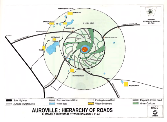
2 Auroville road network as published in the second Master Plan (page 57)
AVToday: What is your background and why did you get involved in drafting a Master Plan for Auroville?
Cristo: Before joining Auroville in 1974, I was working as a trainee transportation engineer in Germany, learning how to design roads and streets. When I joined Auroville, I started a construction service together with Pierre Elouard and others, building houses, schools and workshops. By the end of 1989, I left Auroville to earn money to build a house for myself. I found employment in French Guiana, an overseas department of France on the northeast coast of South America. I was in charge of developing the Sinnamary township near Guiana’s Space Centre, better known as Europe’s Spaceport. This project included not only the construction of all the houses, but also building the roads and infrastructure. It was high-speed work. We managed to get people moving into their new houses within a period of two years. During this time construction also started on a bypass around the launching pad, cutting through dense jungle. We had to ensure that, for security reasons, there would be no development along this road. But of course, it was next to impossible to prevent illegal settlers building along the new highway. My memory of this problem resurfaced when we started working on the Auroville Master Plan many years later.
After I returned to Auroville in 1992 I built my house and was busy with working in the Green Group. Then, in 1994, the first private development happened on privately-owned land in the Green Belt (Sarathas, opposite Courage community). I was extremely distressed and discussed the matter with the then Land Use Coordination Group and with Luigi. The idea came up to start making a Master Plan, as a means to protect the Auroville project. I was tasked with the job of coordinating a team of 15 people who, from 1995 to 1999, prepared the ‘Auroville Universal Township Integrated Master Plan’. This document was approved by the community with an overwhelming majority in July 1999.
After you completed your task what happened?
In August of 1999, the Governing Board, then chaired by Dr Kireet Joshi, though expressing appreciation for the work, felt that eminent town planning authorities at the state and national level needed to be consulted before formally approving the plan and presenting it to the Government of India. Sri Kireet introduced us to the Central Government’s Town and Country Planning Organization (TCPO) in New Delhi. Mr Meshram and Mr Chotani, its Chief Town Planners, agreed to help, as did Mr Dattatri, the former Chief Town Planner of the Chennai Metropolitan authority. Mr Meshram and his officers would stay in Auroville for short periods, while Mr Dattatri came to Auroville a few days each week. They told us to base our work on the ‘Urban Development Plans Formulation and Implementation’ guidelines (UDPFI) of the Ministry of Housing and Urban Affairs of the Government of India, which we did. After four months of further consultation outside and inside Auroville, the ‘Auroville Universal Township Master Plan’, a refinement of the previous document, was finalised. This is a 25-year Perspective or Directional Plan, which contains the broad concepts and philosophies. It prescribes that 5-year development plans need to be made – which can be made once the ground realities are clear – which are then followed by annual plans that are made for implementation.
This plan, the result of a partnership work between the Auroville Foundation and the TCPO, went to New Delhi. It was officialised by the Human Resource Development Minister Shri Murli Manohar Joshi and the Minister of Urban Development and Poverty Alleviation, Shri Jagmohan. The document was subsequently approved by the Governing Board of the Auroville Foundation. For unknown reasons, it was only published in the Gazette of India in 2010.
Were you involved during this entire period?
No, not fully. Once the first Master Plan was achieved I returned to green work but remained active as a Consulting Engineer to the Auroville Development Council, the predecessor of Auroville’s town planning department L’Avenir d’Auroville, now known as the Town Development Council, whenever the need arose. In 2000, I was sent to Europe to present the 1999 Master Plan to the Auroville International Centre in Paris, followed by a presentation at an Auroville International gathering in Germany. But when I came back, I learned that a group of Aurovilians had meanwhile continued the work on the second and now approved Master Plan, which has some significant changes from the 1999 document.
What are these changes?
Most prominent is the road network. The 1999 document mentioned a Crown Road, a circular road to be built at a certain distance around the city centre; an Outer Ring Road in between the city and the greenbelt; and 12 radials roads connecting the Crown Road to the Outer Ring Road. This road design was based on The Mother’s symbol, with the difference that the radials were slightly curved to follow the flowing movement of the galaxy. But many radial roads, and a large part of the Outer Ring Road, were indicated by dotted lines, as we were not sure they should manifest, or might only be built in some areas.
We had considered including some access roads, but we deliberately did not mention them as we did not want any real estate developer purchasing and developing the lands along those future access roads. For that reason, the document only mentions access by the existing roads. This decision was based on my memory of the problem I had faced in Guiana.
The second Master Plan largely followed the road network of the first Plan. But it added four access roads, a decision which dismayed me as I felt it would invite project developers to purchase the lands along these roads and develop them. The novelty of this amended Plan was that the four access roads would terminate at four so-called ‘nodal points’ on the Outer Ring Road, which would serve as transit stations where people could shift to environment-friendly transport to go anywhere within the city. But, like the first Master Plan, the road network within the city, including the outer ring road, was not ‘fixed’; and it was clear that any future bypass roads would have to be located outside the Auroville area, and a rough drawing of the proposed northern and southern bypass was included in the map.
Was there any reference in either master plan to the surrounding villages?
The Perspective Plan does mention the adjoining villages and how they can be integrated within Auroville’s philosophy and development. There were plans to translate the salient features of the Perspective Plan into Tamil, and then meet with village leaders and women’s groups to refine the plans and incorporate their requirements, so that there would be a participatory planning.
What was the role of Roger Anger, who The Mother had appointed as Chief Architect of Auroville in the making of the first and second Master Plan?
Roger was a member of the Governing Board which approved the second Master Plan. But during all the years I served, be it when making the first Master Plan or later as a member of L’Avenir d’Auroville, I do not remember much of his involvement. He was not for any length of time present in Auroville and the contacts with him were mainly through the people who were close to him. He had no direct role nor interfered in the work we were doing. I had only once a personal contact with him, when we discussed the role and the location of some of the radial roads. In these discussions he showed a lot of flexibility. His role, he said, was to set the broad plan of the Galaxy, and the details had to be worked out by others. He was a great man who was, I believe, often greatly misunderstood and sometimes even wrongfully vilified.
What has been the progress since the amended Master Plan was approved by the Governing Board?
Very little. We simply lacked the people with the required professional skills. In 2001, Mr. Dattatri already observed that Auroville was poorly equipped to make Development Plans; and that hasn’t changed. Mr. Dattatri spoke about the need for a professional team consisting of a senior planner, service staff, and quite a few resource people to do surveys and obtain data relating to traffic, sustainable development, economics and so on. But this never manifested. All successive planning groups consisted mainly of Aurovilians, many of them trained architects, full of goodwill, but without planning qualifications. The group chaired by Governing Board member Shri B.V. Doshi was also not able to make much progress.
A few draft development plans were made, but always by non-Aurovilians. Louis Féduchi, a professor from Spain, together with a Polish visitor Kaja Delezuch, made a draft Development Plan for sectors one and two of the Residential Zone, [see AVToday # 308, March 2015, eds.]; David and Achva Stein, landscape architects and town planners from the U.S.A., made a draft Development Plan for the Greenbelt [see AVToday 287, September 2012, eds.]. Andréa Cammarata, an Italian town planner, came to Auroville many times to study the International Zone, and is willing to make a Development plan for this Zone [see AVToday # 356, March 2019, eds.] I loved working with these planners as they are highly qualified. Then there was an Electrical Master Plan made by an engineering company from Calcutta; and Anupama has done a beautiful work on the city centre. But with the exception of the Electrical Master Plan, none of these plans were formally approved and Andréa has not been given permission to start the work. Though his plan was never approved, Féduchi’s work now serves as a basis for developing those sectors of the Residential Zone [see AVToday #369-370, April-May 2020, eds.]
Was there any planning progress with the villages?
That has always been my special interest. For many years we have been working on shared development plans, which led to the creation of Regional Development and Planning Councils with the local Panchayats. [see AVToday # 347-348, June-July 2018, eds.] But the Councils only functioned for about three years as the previous Town Development Council team did not continue the work. This is unwise. It is in Auroville’s interest to work with the six villages around Auroville and create collective infrastructure and road plans.
Let’s go to the present. What was your response when you learned about the plans to now start building the entire Crown Road to a total width of 16.7 metres, which includes two shoulders of 5 metres each, for use by pedestrians, cyclists and public transport?
I became a member of the L’Avenir d’Auroville team in 2009, and from December 2012 to 2018, I was a member of the first Town Development Council. In both teams I was in charge of infrastructure development. The parameters for the study of the section of the Crown Road from the Solar Kitchen to the Mahalakshmi Home were proposed by me and the study and calculations were done in collaboration with Dirk Nagelschmidt of Aqua Engineering. So I know about road widths and infrastructure corridors. But the present plans for the Crown Road have major flaws. I am working on a report to elaborate these mistakes. The simple fact of making a road this wide, of course, is an indication that it may become just an ordinary road.
So you are against the Crown Road?
No. The Crown Road can and should be done. But I see the Crown as an opportunity to create unity if people come together to discuss and agree how best it can be built; but not when it is unilaterally imposed. We need a group of everyone concerned. The top-down approach does not work.
And yes, I have reservations. The first and main one is that the only mobility plan approved by Roger Anger in 2005 has never been reviewed and updated. This plan is clearly made for a city where 50,000 residents are living. No phasing has been incorporated, based on population increase, no survey of existing terrain conditions, etc. The present Town Development Council (TDC) is not working in harmony with the approved Master Plan, as it has not produced any Development Plan, including an actualized mobility plan, to justify the building of this road. It is unbelievable that this is being ignored, and that present-day realities are not being addressed.
These realities are of paramount importance. Today there are about 400 cars in Auroville, up from 76 some 20 years ago, a figure that will increase in the coming years. Many of these cars are owned by elderly Aurovilians, who have no other way to go around. With Auroville having two buses and one minivan, there is no public transport to speak of – and we have no funds to develop it. Increasingly, motorbikes and cars from outside ply the Auroville roads, such as from guests, from people who visit Auroville units, the 7,000 employees, the construction traffic bringing steel and bricks and cement, the courier services and last but not least the through-traffic generated by residents of the surrounding villages using Auroville roads as short cuts. And if in the next few years 4,000 new people join Auroville, as is being promoted by some people, they will bring their own cars and motorbikes and create additional mobility issues.
But there is no discussion on what traffic Auroville is willing to accept. Do we want cars like everywhere else? If so, we need to plan for parking spaces along the roads and build large parking garages. These are the questions I was asking my colleagues at TDC and later L’avenir during the 14 years I worked in these organizations, but I never got any indication as to the direction our studies were to take. The choices we make today on mobility will define the way Auroville will develop in the next 25 to 50 years: towards the City the Earth Needs or just towards becoming another ordinary city for tourists and business.
What are your views about the Outer Ring Road?
I was shocked when I read the response of the TDC to a question of Auroville Today on how the TDC envisages the Outer Ring Road [issue # 387, October 2021, eds]
“For the very reason that the outer ring road passes through adjoining villages, it is important that it remains public and accessible to all. This road will receive traffic from the access roads that would connect the Pondicherry – Tindivanamn Highway and the East Coast Road. The main purpose of this road in the context of Auroville is (1) to connect the four zones on the peripheral side of the city and (2) to divert the non-Auroville bound traffic from entering the city.”
This, for me, is complete nonsense. In the same para there are two contradictory proposals. It goes against what The Mother said about traffic in Auroville. It goes against the Master Plan which says that the four main access roads would terminate at nodal points outside of the greenbelt from where people could shift to environment-friendly transport to go anywhere within the city (clearly meaning no private car ownership). It goes against the vision expressed in the Master Plan that any future bypass roads would have to be located outside the Auroville area. Also, the Outer Ring Road as planned by the TDC would bring all the endemic problems connected to highway development into Auroville, such as the air and noise pollution. And on lands not owned by Auroville, e.g. the lands in the Greenbelt, there will be strip commercial development with the accompanying issues of garbage dumping, excessive water extraction, groundwater pollution, and social issues like alcoholism, violence and prostitution. And I am not even speaking about the fact that such a road would destroy large parts of established forest growth in the Greenbelt and the many Auroville communities that border it.
Does this mean that you consider the Outer Ring Road to be a wrong concept?
Yes, in the way it is understood by the TDC today. There are safer alternatives to the imperfect circle that defines the Outer Ring Road. One of these is to segregate traffic. The southern part of the Outer Ring Road from Sharnga to Edaiyanchavadi should be built, but only used by Aurovilians and those who need to visit Auroville. It would have a single connection to the Kuilapalayam – Edaiyanchavadi tar road, which will continue to be the bypass road between the East Coast Road and the Pondicherry-Tindivanam highway. In this way a part of the Outer Ring Road would serve Auroville, without inviting all non-Auroville traffic. Another access point is needed for the Industrial Zone.
What are your reflections on the future?
It took many years of hard work to come to the Auroville Universal Township Master Plan Perspective 2001-2025. Now, as we are almost in 2022, I would advise the making of a Detailed Development Plan for the next five years that will serve as the basis for a new Perspective Master Plan. And I wouldn’t go for another 25-Years’ Plan but for a 10-Year Plan based on the realities of the year 2025. Let the community and Governing Board together decide the mobility, the food distribution, the zones and entertainment areas, all what we really need. Then make an assessment every two years of what worked and what didn’t, and adjust where necessary. And let Auroville hire professional town planners and appoint an Auroville Interface Team to be the liaison between these professional town planners and the community.
Are you frustrated by the slow pace of development and what’s happening today?
Not really. If anything, Mother India has taught me patience. The true development of Auroville is not measured in the number of buildings and roads that have come up, but in the increasing manifestation of human unity and the development of people’s consciousness. I think I see that happening, particularly in children.
Regarding today’s developments: much as I welcome and admire the drive to acquire all the lands within the Township Area of Auroville, which is absolutely necessary for the manifestation of Auroville, I do not agree with building a road network without a mobility plan and without a harmonious community involvement. I learned from Mr. Dattatri, who I loved dearly, that in Tamil Nadu the best approach towards any successful development is from bottom up, particularly when dealing with the administration and the village elders.
Regarding myself: I’ve spent 47 years in Auroville, and have gone through many very severe downs and some ups. A certain level of equanimity has developed and a ground for the development of a new consciousness has been laid. This, for me, is the only reason why I am still here, to further develop myself and serve the ideal of The Mother and Sri Aurobindo.